SERVICES

MINING
Mining and Environmental Licensing of Mines
Regional and Detail Survey and Mapping
Geologic, Geophysical and Geochemical Modelling
Mineral Prospection
Dispatch of Brazilian legal requirements for mining

APPLIED HYDROLOGY AND HYDROGEOLOGY
Licensing and Granting the Use of Water Resources
Construction, Maintenance and Monitoring of Wells
Geological, Geophysical and Geochemical Survey for Groundwaters
Hydrological and Hydrogeological Modelling

ENVIRONMENTAL
Environmental Licensing and Monitoring (LAR, LP, LI, LO, LOR, TE)
Environmental Register (IBAMA, ANP, ANM)
Menagement and Recovery of Degraded Areas (PRAD), Intervention or Monitoring Environmental Plains
Waste Management
Environmental Passive Studies (EPA)
Studies of Environmental Impacts and Risk (AIA, EIA-RIMA)
Environmental Expertise

ROCK and SOIL ENGINEERING
Infiltration Essay
Sntandard Penetration Essay (SPT, SPTt)
Massif Geotechnical Characterization and Classification
Drainage and Microdrainage

GEOCHEMISTRY
Geochemistry analysis for mineral, hydrogeological and environmental Research
Microchemistry Analysis (RDX, EDX and LIBS)

GEOPHYSICS
Geophysical Analysis for Mining and Environmental Research
Survey and Interpretation of Gamaespectrometry and Magenetic Data
Electric Surveys

BIOSTRATIGRAFY
Collect and Preparation of Samples (Organica, Calcareous and Siliceous Microfossils)
Reading and Interpretation os Paleontological Slices
Foraminifera, Ostracoda, Calcareous Nannofossils and Palynomorphs
Taxonomic, Biostratigraphic and Paleoecological Interpretations
Palynofacies and Organic Facies Analyses

TOPOGRAPHY
Precision Planialtimetric Surveys
Rural Register (CAR and SIGEF)
Geomorphological, Geological and Tematic Cartography

GEOPROCESSING
Remote Data Analyse and interpretation
Geomorphological, Geological and Tematic Mapping
Segmentation and Classification of Terrain
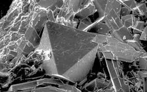
IMAGING
Optical Imaging by Normal and Polarized Transmited Light
Optical Imaging by Normal and Fluorescent reflected Light
Scanning Electron Microscopy (SEV)

2D e 3D PRODUCTS
Blue Prints
Sketches
3D Environments
Tematic Models

MANAGEMENT AND PLANNING
Technical and scientific advice for public and private Managers
Elaboration of Geopolitical Strategy Plans for managers